England & Wales 1716 Johann Baptist Homann Unusual Antique Copper Engraved MapANTIQUE COPPER ENGRAVED MAP OF ENGLAND & WALES 1716
$ 13.73
Description
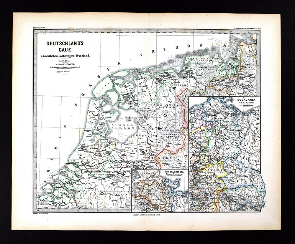
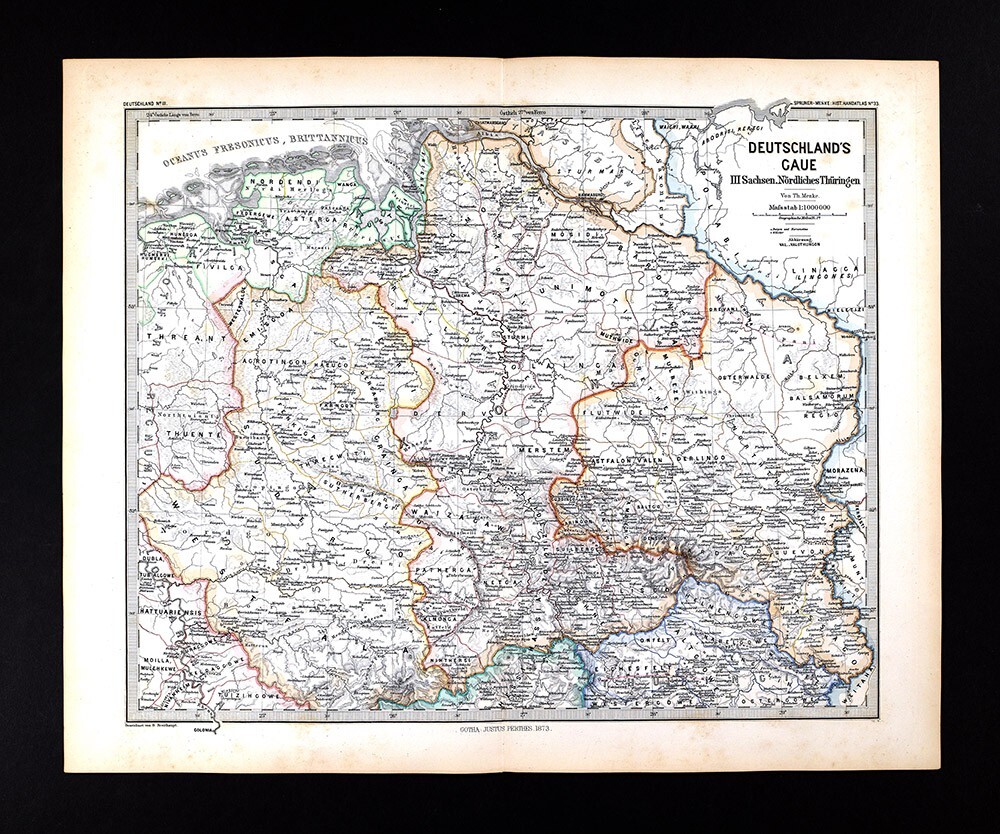
ENGLAND & WALES 1716 JOHANN BAPTIST HOMANN UNUSUAL ANTIQUE COPPER ENGRAVED MAP. Johann Baptist Homann (March 20, 1664 - July 1, 1724) was the most prominent and prolific map publisher of the 18th century. Homann was born in Oberkammlach, a small town near Kammlach, Bavaria, Germany. ENGLAND & WALES 1716 JOHANN BAPTIST HOMANN UNUSUAL ANTIQUE COPPER ENGRAVED MAP ENGLAND & WALES 1716 JOHANN BAPTIST HOMANN UNUSUAL ANTIQUE COPPER ENGRAVED MAP Description Magnæ Britanniæ Pars Meridionalis in qua Regnum Angliæ tam in septem antiqua Anglo-Saxonum regna quom in omnes Hodiernas Regiones accurate divisum hic ostenditur quam tabula ab archetypo Vischeriano desumptam exhibet Ioh. Bapt. Homan Noribergæ. Description: Striking and highly detailed fine unusual 1716 Johann Baptist Homann's copper engraved map of England & Wales. Covers also southern part of Scotland, eastern coast of ireland and part of northern coast of France . The map features excellant topographic details on cities, towns, rivers, lakes, reliefs and islands. This handsome map is based upon Visscher's map of 1695, delineating counties and showing the boundaries of the seven Anglo-Saxon kingdoms. The map is decorated by a beautiful cartouche surrounded by angels and the British coat of arms. Two other angels hold the Welsh armorial shield, and at bottom is a large vignette of the king holding court. The map is densely engraved with detail including roads. This is the first state of the map with Homann's privilege. References: Shirley (BI to 1750) Homann 3. Date: 1716 ( undated ) Dimension: Map size approx.: cm 51,4 x 61,8 Condition: Very strong and dark impression on good paper. Paper with chains and wiremarks. Map old original colored. Cartouches contemporary handcolored. Small foxing and browning. Small moisture signs. Map folded. Conditions are as you can see in the images. Mapmakers: Johann Baptist Homann (March 20, 1664 - July 1, 1724) was the most prominent and prolific map publisher of the 18th century. Homann was born in Oberkammlach, a small town near Kammlach, Bavaria, Germany. As a young man Homann studied in a Jesuit school and nursed ambitions of becoming a Dominican priest before converting to Protestantism in 1687. Following his conversion, Homann moved to Nuremberg and found employment as a notary. Around 1693 Homan briefly relocated to Vienna, where he lived and studied printing and copper plate engraving until 1695. Afterwards he returned to Nuremberg where, in 1702, he founded the commercial publishing firm that would bear his name. In the next five years Homann produced hundreds of maps and developed a distinctive style characterized by heavy detailed engraving, elaborate allegorical cartouche work, and vivid hand color. The Homann firm, due to the lower cost of printing in Germany, was able to undercut the dominant French and Dutch publishing houses while matching the diversity and quality of their output. By 1715 Homann's rising star caught the attention of the Holy Roman Emperor Charles the VI, who appointed him Imperial Cartographer. In the same year he was also appointed a member of the Royal Academy of Sciences in Berlin. Homann's prestigious title came with a number of important advantages including access to the most up to date cartographic information as well as the "Privilege". The Privilege was a type of early copyright offered to a few individuals by the Holy Roman Emperor. Though not as sophisticated as modern copyright legislation, the Privilege did offer a kind of limited protection for several years. Most all J. B. Homann maps printed between 1715 and 1730 bear the inscription "Cum Priviligio" or some variation. Following Homann's death in 1726, the management of the firm passed to his son Johann Christoph Homann (1703 - 1730). J. C. Homann, perhaps realizing that he would not long survive his father, stipulated in his will that the company would be inherited by his two head managers, Johann Georg Ebersberger and Johann Michael Franz, and that it would publish only under the name Homann Heirs. This designation, in various forms (Homannsche Heirs, Heritiers de Homann, Lat Homannianos Herod, Homannschen Erben, etc..) appears on maps from about 1731 onwards. The firm continued to publish maps in ever diminishing quantities until the death of its last owner, Christoph Franz Fembo in 1848. The Visscher Family For nearly a century, the members of the Visscher family were important art dealers and map publishers in Amsterdam. Claes Jansz. Visscher, or N.J. Piscator (1587-1652) Claes Jansz. Vischer bought a house in Amsterdam, 'de gulden Bors', on the important Kalverstraat and changed the name into "In de Visscher" and it was under this title that the shop was to flourish for many years. He was famous for his engravings and etchings of Dutch landscape and of 'historical scenes', such as sieges, battles, etc. These 'historical scenes' were considered as contemporary illustrated news items, especially, e.g., that of 'the Eighty Years' War'. For the publication of his first atlas, he bought copperplates of the atlas Germania Inferior by Pieter van den Keere (1623). In 1649, he published an atlas entitled Tabularum Geographicarum Contractarum, containing the same maps as Langenes' Caert Thresoor, for which Visscher had only new title-pages engraved. Claes Jansz. Visscher died in 1652. His wife, Neeltjen Florisdr., had already died in 1640. They had seven children, four of whom were still alive at Claes Jansz.'s death. One of them was Nicolaes Visscher I, who was to continue his father's business. Nicolaes Visscher I (1618-1679) Nicolaes Visscher I entered into a partnership with his father and continued the business and stayed on the Kalverstraat 'in de Visscher' till his death. About 1657, the first edition appeared of his Atlas Contractus Orbis Terrarum. Between 1664 and 1677, several editions of his Atlas Contractus appeared without a printed index, for these atlases had no fixed contents, but were composed according to the buyer's financial leaping-pole. In May 1664, Nicolaes Visscher was admitted as a member of the Booksellers' Guild of his town. In July 1677, he was granted a patent of the States of Holland and West-Friesland for the printing and publishing of maps and atlases for a period of 15 years. After this, he again published an Atlas Contractus, this time with a printed index. At about the same time, he also brought out an Atlas Minor. Nicolaes Visscher II (1649-1702) Nicolaes Visscher II inherited the 'shop' from his father. To obtain a new privilege he applied to the States of Holland and West-Friesland in 1682, for a patent for printing and publishing maps. This patent was granted to him the same year. He moved the firm to the Dam, but it kept the same signboard: "In de Visscher". Around 1683, he published his first Atlas Minor with a printed index of 91 maps. In 1684, an atlas Germania Inferior appeared. Till 1697 he published another number of atlases. He used his grandfather's (Claes Jansz.) maps less often now and relied more and more on his own. The wars waged in this time initiated the compilation of maps of the countries where the armies were operating. Many maps of war were included in the various editions of his Atlas Minor. After Nicolaes' death, his wife, Elizabeth Verseyl, published all the maps of war in the form of an atlas under the title: De Stoel des Oorlogs in de Wereld (The seat of war in the world). The widow of Nicolaes Visscher II (?-1726) His widow continued the business energetically, and by her hand, under the name of her deceased husband, numerous atlases appeared, e.g., several editions of the Atlas Minor, an Atlas Maior and De Stoel des Oorlogs. The shop enjoyed a high reputation owing to the great variety of the assortment. Not only 'Visscher' maps, but also maps of other publishers were obtainable. With the death of Elizabeth Verseyl, in 1726, the last descendant died of a great map- and atlas-publishing firm in Amsterdam. All of the maps we sell are ORIGINALS. We guarantee all of our maps to be authentic. We do our best to describe the condition of our maps as accurately as possible. Due to the age and type of paper, some imperfections are to be expected. Please examine the images provided carefully, and if you have any questions please ask and we will be happy to help. A Certification of Authenticity ( COA ) can be issued on request I will send you all your item by FedEx/DHL with covering Insurance If you buy more than one item you have to pay just one only shipping cost Any map purchased from us may be returend for any reason for a full refund. Shipping: Customs may be charged on international shipments. All customs charges are the responsiblity of the buyer and are not included in the selling price. All goods destined for the United States are exempt from any taxation. About: Old Times Rare Antiquarian Books & Maps Sellers Our Firm was founded in 1983 and we are specialized on antiquarian works on paper concerning Antique Rare Maps, Atlases and Travel Books of all the World. Our Firm adheres to the Codes of Ethics outlined by the Italian Antiquarian Booksellers Association ( ALAI ) and International League of Antiquarian Booksellers ( ILAB ). All items sold by OLD TIMES are genuine and a Certificate of Authenticity (COA) will be happily supplied on request. Many Thanks View My Feedback View My Other Items For Sale View My About Me page Visit My eBay Store Add me to your Favorite Sellers Click images to enlarge Images sell! Get Supersized Images & Free Image Hosting Create your brand with Auctiva's Customizable Templates. Attention Sellers - Get Templates Image Hosting, Scheduling at Auctiva. Track Page Views With Auctiva's Counter