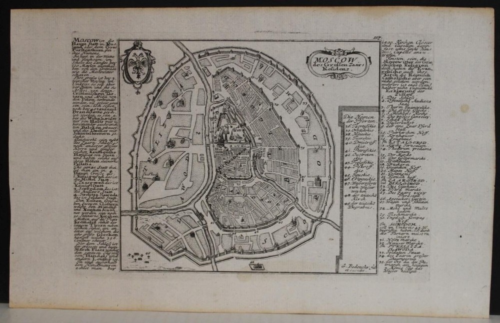
Muscovy European Russia 1561 Ruscelli Unusual Antique Copper Engraved MapANTIQUE COPPER ENGRAVED MAP OF THE EUROPEAN RUSSIA
$ 13.73
Description
MUSCOVY EUROPEAN RUSSIA 1561 RUSCELLI UNUSUAL ANTIQUE COPPER ENGRAVED MAP. One of the earliest published maps of Russia. One of the earliest published maps of Russia. MUSCOVY EUROPEAN RUSSIA 1561 RUSCELLI UNUSUAL ANTIQUE COPPER ENGRAVED MAP MUSCOVY EUROPEAN RUSSIA 1561 RUSCELLI UNUSUAL ANTIQUE COPPER ENGRAVED MAP Description Moschovia Nuova Tavola. Description: Striking and highly detailed very interesting 1561 Girolamo Ruscelli’s copper engraved map of Moscovie. Covers modern day Russia and the Ukraine from the Arctic to the Crimea and as far east as the Caspian Sea. Interest in this area peaked in Western Europe following the discoveries of Barentz, Hudson, and others in Russian Arctic which lead to the founding of the Muscovy Company in 1555. Traders, mostly English and Dutch, discovered they could access the wealth of Eastern and Central Asia by traveling south of Nova Zembla to the Karo Sea, then south some 600 miles by river to Moscow. At this time the Russian Tzar did not yet have access to the Baltic and consequently was at the mercy of the Hanseatic League, which controlled much of the region's trade. The opening of an Arctic route to Russia and the foundation of the Muscovy Company generated enormous wealth for the princes of Russia, eventually bringing the country into the fold of the western European community. Essentially a Ptolemaic style projection, this map was engraved by Girolamo Porro and published as part of Ruscelli's Italian translation of Ptolemy's Geographia. This map is considered one of the 'New Ptolemys,' that is, one of the 38 maps of the modern world drawn by Ruscelli's to supplement the original 27 maps that traditionally existed based upon Ptolemy's texts. Source: La Geografia di Claudio Tolomeo Alessandrino, nuouamente tradotta di Greco in Italiano, da Girolamo Ruscelli; con Espositioni del medesimo, particolari di luogo in luogo, & uniuersali sopra tutto il libro, et sopra tutta la Geografia, o modo di far la descrittione di tutto il mondo ; et con nuoue & bellisime figure in istampe di rame, oue, oltre alle XXVI antiche di Tolomeo, se ne son'aggiunte XXXVI altre delle moderne; con la carta da nauicare, & col modo d'intenderla, & d'adoperarla; aggiuntoui un pieno discorso di M. Gioseppe Moleto matematico; nel quale si dichiarano tutti i termini & le regole appartenenti alla Geografia et con una nuoua & copiosa tauola di nomi antichi, dichiarati coi nomi moderni, & con molte altre cose utillissime & necessarie, che ciascuno leggendo potra conoscere. Al Sacratissimo et Sempre Felicissimo Imperator Ferdinando Primo. Con privilegio dell'Illustrissimo Senato Veneto, & d'altri Principi per anni XV. In Venetia, Appresso Vincenzo Valgrisi, M.D.LXI. (1561) . Date: 1561 ( undated ) Dimension: Paper size approx.: cm 32,6 x 22,8 Condition: Very strong and dark impression on good paper . Paper with chains and wiremarks. Sheet uncolored. Small foxing. Small holes. Map folded. Conditions are as you can see in the images. Cartographers: Girolamo Ruscelli (1500-1566) was a cartographer, humanist, and scholar from Tuscany. Ruscelli was a prominent writer and editor in his time, writing about a wide variety of topics including the works of Giovanni Boccaccio and Francesco Petrarch, Italian language, Italian poetry, medicine, alchemy, and militia. One of his most notable works was a translation of Ptolemy’s Geographia which was published posthumously. There is limited information available about Ruscelli’s life. He was born in the Tuscan city of Viterbo to a family of modest means. He was educated at the University of Padua and moved between Rome and Naples until 1548, when he moved to Naples to work in a publishing house as a writer and proofreader. He remained in the city until his death in 1566. Claudius Ptolemy (90 A.D.-168 A.D.) was a celebrated astronomer, mathematician, and geographer who lived in Alexandria in the 2nd century AD. Although his thinking influenced contemporary Arab geographers, little was known of his work in the West until manuscripts from Constantinople reached Italy in about 1400. These manuscripts were written in Greek and contained the names of every city, island, mountain and river known to the many travellers interviewed by Ptolemy. In addition, the latitude and longitude of each of the resulting eight thousand locations were also recorded. They were translated into Latin by 1401 and appeared in print by 1475. The earliest Byzantine manuscript maps, drawn by analysing the Ptolemy figures, date from the twelfth century. A number of hand-drawn copies were made in Italy throughout the early fifteenth century to accompany Ptolemys text. Ptolemy stressed the importance of accurate observations in order to calculate latitude and longitude, and laid down the principals of systematic cartography that remain to this day. Obviously there are many errors in Ptolemys maps, due to the limited extent of basic geographic information at that time and the lack of a method of determining accurate longitudes. Judged by modern standards, the basic shortcoming of the Ptolemy world map is the small area it portrays. The Mediterranean is fairly well depicted, but is greatly exaggerated in length (Longitudinally). The effect of this, combined with Ptolemys disregard for Eratosthenes extremely accurate estimate of the earths circumference (c. 200 B.C.) and the use of a Posidonius much smaller flawed estimate (c.50 B.C.) implied a much shorter distance across that part of the unknown earths surface not drawn on the map. Columbus and his contemporaries based their exploratory ventures on Ptolemys calculations and, like him, had no idea of the vast New World to the west, interposed between Europe and Asia. Work on the first printed atlas from the text of Ptolemy was started in 1473 and finally published in 1478. A crude copy of this atlas was produced and published by some dissident workers in 1477 in order to be first. However, the plates for the 1478 were done prior to the pirated issue and thus the 1478 atlas holds the title of the first Atlas of the world. There are very few surviving examples of this atlas and individual maps. All of the maps we sell are ORIGINALS. We guarantee all of our maps to be authentic. We do our best to describe the condition of our maps as accurately as possible. Due to the age and type of paper, some imperfections are to be expected. Please examine the images provided carefully, and if you have any questions please ask and we will be happy to help. A Certification of Authenticity ( COA ) can be issued on request I will send you all your item by FedEx/DHL with covering Insurance If you buy more than one item you have to pay just one only shipping cost Any map purchased from us may be returend for any reason for a full refund. Shipping: Customs may be charged on international shipments. All customs charges are the responsiblity of the buyer and are not included in the selling price. All goods destined for the United States are exempt from any taxation. About: Old Times Rare Antiquarian Books & Maps Sellers Our Firm was founded in 1983 and we are specialized on antiquarian works on paper concerning Antique Rare Maps, Atlases and Travel Books of all the World. Our Firm adheres to the Codes of Ethics outlined by the Italian Antiquarian Booksellers Association ( ALAI ) and International League of Antiquarian Booksellers ( ILAB ). All items sold by OLD TIMES are genuine and a Certificate of Authenticity (COA) will be happily supplied on request. Many Thanks View My Feedback View My Other Items For Sale View My About Me page Visit My eBay Store Add me to your Favorite Sellers Click images to enlarge Pictures sell! Auctiva offers Free Image Hosting and Editing. 300+ Listing Templates! Auctiva gets you noticed! The complete eBay Selling Solution. Track Page Views With Auctiva's Counter