Departure Of William Iii Of Orange Netherlands1698 Merian Unusual Antique ViewANTIQUE COPPER ENGRAVED VIEW OF WILLIAM III OF ORNAGE
$ 41.72
Description
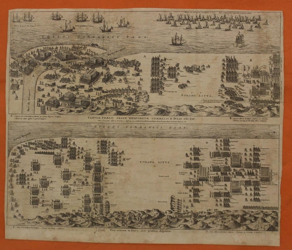
DEPARTURE OF WILLIAM III OF ORANGE NETHERLANDS1698 MERIAN UNUSUAL ANTIQUE VIEW. After his father's death, he ran the Frankfurt publishing house together with his brother Matthäus the Younger. In 1677, he moved to West Friesland and joined the radical Protestant Labadist community, with whom he lived until his death. DEPARTUR OF WILLIAM III OF ORANGE NETHERLANDS1698 MERIAN UNUSUAL ANTIQUE VIEW DEPARTUR OF WILLIAM III OF ORANGE NETHERLANDS1698 MERIAN UNUSUAL ANTIQUE VIEW Description S. K. H. gehet zu Schiff in Engelland über Zufahren. Description: Striking and highly detailed interesting unusual copper engraved view depicting the departure of Wilhelm III of Oranien with his fleet, leaving to conquer England in November 1688. Very detailed view showing many ships in great detail, Wilhelm further with people loading goods on the pier. With a legend explaining 13 points (A-M). The scene documents the beginning of the Glorious Revolution, a pivotal event that led to the deposition of James II and the accession of William III and Mary II as co-rulers of the English throne. The scene shows the vast invasion fleet, consisting of approximately 50 warships and hundreds of transports, ready to set sail from Hellevoetsluis in the Netherlands. This moment marked the height of religious and political tensions in England; William was urged by Protestant nobles to intervene to preserve Protestantism and the kingdom's liberties. Result: The fleet landed at Brixham, Devon, on November 5 (according to the Julian calendar then in use in England), and the expedition concluded almost bloodlessly. Having been invited to seize the throne by opponents of King James II, William landed at Brixham on 15 November 1688. He believed his 14,000 veterans could defeat any force that James could throw at him, but decided to avoid the hazards of battle and maintain a defensive attitude in the hope that James's position might collapse by itself. Date: 1698 ( undated ) Dimension: Plate size approx.: cm 40,4 x 33,9 Condition: Very strong and dark impression on good paper. Paper with chains. Map uncolored. Small foxing and browning. Tear at the top near central folding. Sheet folded. Conditions are as you can see in the images. Mapmakers: Matthäus Merian (September 22, 1593 - June 19, 1650), sometimes referred to as 'the Elder' to distinguish from his son, was an important Swiss engraver and cartographer active in the early to mid 17th century. Merian was born in Basel and studied engraving in the centers of Zurich, Strasbourg, Nancy and Paris. In time Merian was drawn to the publishing mecca of Frankfurt, where he met Johann Theodor de Bry, son of the famed publisher Theodor de Bry (1528 - 1598) . Merian and De Bry produced a number of important joint works and, in 1617, Merian married De Bry's daughter Maria Magdalena. In 1623 De Bry died and Merian inherited the family firm. Merian continued to publish under the De Bry's name until 1626. Around this time, Merian became a citizen of Frankfurt as such could legally work as an independent publisher. The De Bry name is therefore dropped from all of Merian's subsequent work. Of this corpus, which is substantial, Merian is best known for his finely engraved and highly detailed town plans and city views. Merian is considered one of the grand masters of the city view and a pioneer of the axonometric projection. Merian died in 1650 following several years of illness. He was succeeded in the publishing business by his two sons, Matthäus (1621 - 1687) and Caspar (1627 - 1686), who published his great works, the Topographia and Theatrum Eruopeaum, under the designation Merian Erben (Merian Heirs). Merian daughter, Anna Maria Sibylla Merian, became an important naturalist and illustrator. Today the German Travel Magazine Merian is named after the famous engraver. Caspar Merian (born February 13, 1627 in Frankfurt am Main; died April 12, 1686 in Waltha Castle, Province of Friesland) was one of the most important topographical engravers and publishers of the Baroque period. He came from the Frankfurt branch of the Basel-based Merian family. Caspar Merian was a son and pupil of the engraver Matthäus Merian the Elder (1593–1650) and his wife Maria Magdalena née de Bry. As an assistant to his father, he worked for a time in Paris and Nuremberg. After his father's death, he ran the Frankfurt publishing house together with his brother Matthäus the Younger. Both continued the publication of the main works begun by their father, the "Topographia Germaniae" and the "Theatrum Europaeum", and produced numerous further engravings for them. In 1672, on medical advice, Merian retired to Wertheim. In 1677, he moved to West Friesland and joined the radical Protestant Labadist community, with whom he lived until his death. In 1685, he also took in his half-sister Maria Sibylla Merian (1647–1717), her mother Johanna Catharina Sibylla née Heim, and his sister's two daughters at his Waltha Castle. All of the maps we sell are ORIGINALS. We guarantee all of our maps to be authentic. We do our best to describe the condition of our maps as accurately as possible. Due to the age and type of paper, some imperfections are to be expected. Please examine the images provided carefully, and if you have any questions please ask and we will be happy to help. A Certification of Authenticity ( COA ) can be issued on request I will send you all your item by FedEx/DHL with covering Insurance If you buy more than one item you have to pay just one only shipping cost Any map purchased from us may be returend for any reason for a full refund. Shipping: Customs may be charged on international shipments. All customs charges are the responsiblity of the buyer and are not included in the selling price. All goods destined for the United States are exempt from any taxation. About: Old Times Rare Antiquarian Books & Maps Sellers Our Firm was founded in 1983 and we are specialized on antiquarian works on paper concerning Antique Rare Maps, Atlases and Travel Books of all the World. Our Firm adheres to the Codes of Ethics outlined by the Italian Antiquarian Booksellers Association ( ALAI ) and International League of Antiquarian Booksellers ( ILAB ). All items sold by OLD TIMES are genuine and a Certificate of Authenticity (COA) will be happily supplied on request. Many Thanks View My Feedback View My Other Items For Sale View My About Me page Visit My eBay Store Add me to your Favorite Sellers Click images to enlarge Get images that make Supersized seem small. Showcase your items with Auctiva's Listing Templates! THE simple solution for eBay sellers. Track Page Views With Auctiva's Counter