Scandinavian Peninsula 1689 Sanson/De' Rossi Unusual Antique Copper Engraved MapANTIQUE COPPER ENGRAVED MAP OF SCANDINAVIAN PENINSULA
$ 13.73
Description
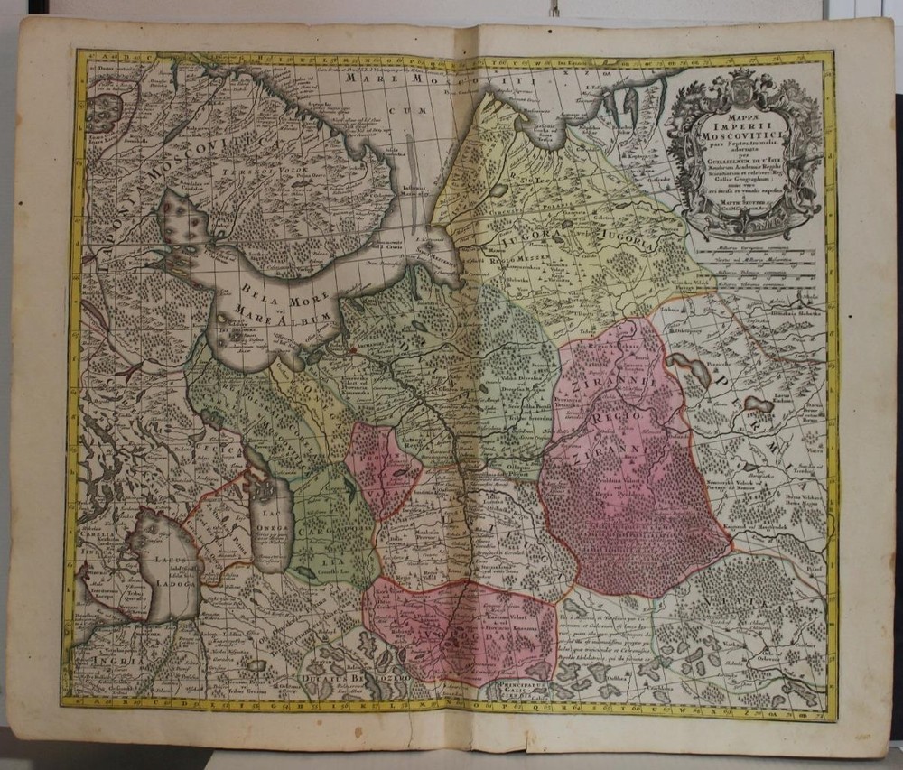
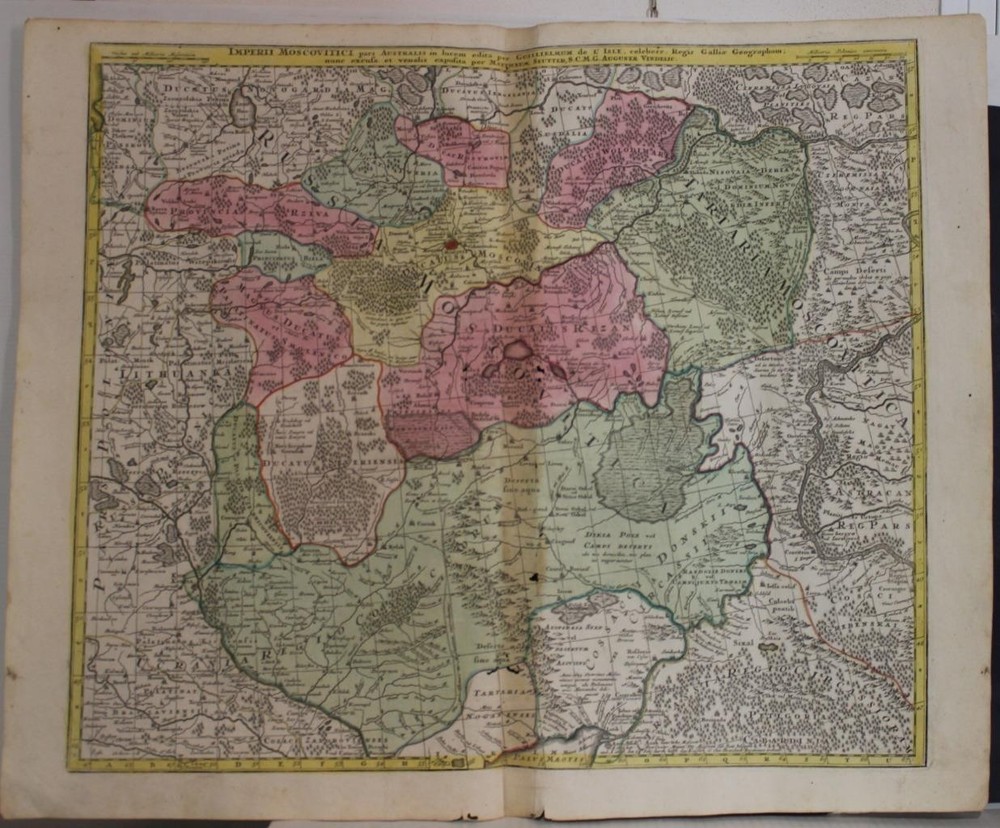
SCANDINAVIAN PENINSULA 1689 SANSON/DE' ROSSI UNUSUAL ANTIQUE COPPER ENGRAVED MAP. Sanson was also an active proponent of the insular California theory, wherein it was speculated that California was an island rather than a peninsula. The map covers Sweden, Denmark, Norway, Finland, Latvia, Estonia, northern Germany, north Poland, Lithuania and part of Russia. SCANDINAVIAN PENINSULA 1689 SANSON/DE' ROSSI UNUSUAL ANTIQUE COPPER ENGRAVED MAP SCANDINAVIAN PENINSULA 1689 SANSON/DE' ROSSI UNUSUAL ANTIQUE COPPER ENGRAVED MAP Description La Scandinavia Divisa nelli suoi Regni di Svezia, Danimarca, Norvegia e Paese dei Lapponi. Subdivisa nelle sue principali Provincie Per Guglielmo Sansone Geografo del Re Chistianissimo e di nuovo disegnata da Gio. Batta Falda e data in luce da Gio. Giacomo Rossi In Roma alla Pace con Priv, del S. Pon. l'Anno 1689. Description: Striking and highly detailed fine unusual 1689 Giovanni Giacomo de' Rossi 's edition of the Giovanni Battista Falda & Nicolas Sanson's copper engraved map of the Scandinavian Peninsula. The map covers Sweden, Denmark, Norway, Finland, Latvia, Estonia, northern Germany, north Poland, Lithuania and part of Russia. The map notes cities, towns, villages, rivers, lakes, fjords, forests and islands. Elegant title cartouche at the top left quadrant . Date: 1689 ( dated ) Dimension: Paper size approx.: cm 62,9 x 49,9 Condition: Very strong and dark impression on good paper. Paper with chains and wiremarks. Map old original colored. Wide margins. Sheet browned at the lower side. Small tears. Map folded. Conditions are as you can see in the images . Mapmakers: Nicolas Sanson (1600 - 1667) and his descendants were the most influential French cartographers of the 17th century and laid the groundwork for the Golden Age of French Cartography. Sanson started his career as a historian where, it is said, he turned to cartography as a way to illustrate his historical studies. In the course of his research some of his fine maps came to the attention of King Louis XIII who, admiring the quality of his work, appointed Sanson Geographe Ordinaire du Roi. Sanson's duties in this coveted position included advising the king on matters of geography and compiling the royal cartographic archive. In 1644 he partnered with Pierre Mariette, an established print dealer and engraver, whose business savvy and ready capital enabled Sanson to publish an enormous quantity of maps. Sanson's corpus of some three hundred maps initiated the golden age of French mapmaking and he is considered the 'Father of French Cartography.' His work is distinguished as being the first of the 'Positivist Cartographers,' a primarily French school of cartography that valued scientific observation over historical cartographic conventions. The practice result of the is less embellishment of geographical imagery, as was common in the Dutch Golden Age maps of the 16th century, in favor of conventionalized cartographic representational modes. Sanson is most admired for his construction of the magnificent atlas Cartes Generales de Toutes les Parties du Monde. Sanson's maps of North America, Amerique Septentrionale (1650), Le Nouveau Mexique et La Floride (1656), and La Canada ou Nouvelle France (1656) are exceptionally notable for their important contributions to the cartographic perceptions of the New World. Both maps utilize the discoveries of important French missionaries and are among the first published maps to show the Great Lakes in recognizable form. Sanson was also an active proponent of the insular California theory, wherein it was speculated that California was an island rather than a peninsula. After his death, Sanson's maps were frequently republished, without updates, by his sons, Guillaume (1633 - 1703) and Adrien Sanson (? - 1708). Even so, Sanson's true cartographic legacy as a 'positivist geographer' was carried on by others, including Alexis-Hubert Jaillot, Guillaume De L'Isle, Gilles Robert de Vaugondy, and Pierre Duval. Giovanni Battista Falda (Valduggia 7 December 1643–22 August 1678, Rome) was an Italian architect, engraver, and artist. He is known for his engravings of both contemporary and antique structures of Rome. Falda was sent as a boy to Rome, to work in the studio of Bernini, and his draughtsmanship caught the eye of the publisher Giovanni Giacomo de Rossi. He engraved for Le fontane di Roma (Fountains in Rome) and for Palazzi di Roma (Palaces of Rome). The former books were expanded after Falda's death with engravings by Francesco Venturini. The latter was published in 1655 in collaboration with Pietro Ferrerio. He is sometimes known as 'Falda da Valduggia' because of his birthplace. His works became particularly popular with the first waves of Grand Tour participants during the latter parts of the 17th century, and Falda became a commercial success as a result. His works appealed to tourists keen to retain a detailed and accurate representation of those parts of Rome they had visited. Giovanni Giacomo de Rossi (1627 – 1691) was an Italian engraver and printer, active in Rome in the second half of the 17th century. His father, Giuseppe de Rossi (1570-1639), was the founder of the most important and active printing press of the 17th century in Rome. The printing press begun in 1633, by Giuseppe de Rossi, and it passed firstly to Giovanni Giacomo and to his brother Giandomenico (1619-1653), and then later to Lorenzo Filippo (1682-?); in 1738 it became the Calcografia Camerale, from 1870 until 1945 the Regia Calcografica, and today it is known as the Calcografia Nazionale. Here are conserved, amongst many others, the plates of Giambattista Piranesi (1720-1778). Giovanni Giacomo de Rossi was the most involved of all the various family members who ran the press, and he worked between 1638 and 1691, and was to take the company to the height of its success. The artists that he printed the etchings for included Giovanni Benedetto Castiglione (1609-1665), Pietro Testa (1612-1650) and Giovan Francesco Grimaldi (1606–1680). All of the maps we sell are ORIGINALS. We guarantee all of our maps to be authentic. We do our best to describe the condition of our maps as accurately as possible. Due to the age and type of paper, some imperfections are to be expected. Please examine the images provided carefully, and if you have any questions please ask and we will be happy to help. A Certification of Authenticity ( COA ) can be issued on request I will send you all your item by FedEx/DHL with covering Insurance If you buy more than one item you have to pay just one only shipping cost Any map purchased from us may be returend for any reason for a full refund. Shipping: Customs may be charged on international shipments. All customs charges are the responsiblity of the buyer and are not included in the selling price. All goods destined for the United States are exempt from any taxation. About: Old Times Rare Antiquarian Books & Maps Sellers Our Firm was founded in 1983 and we are specialized on antiquarian works on paper concerning Antique Rare Maps, Atlases and Travel Books of all the World. Our Firm adheres to the Codes of Ethics outlined by the Italian Antiquarian Booksellers Association ( ALAI ) and International League of Antiquarian Booksellers ( ILAB ). All items sold by OLD TIMES are genuine and a Certificate of Authenticity (COA) will be happily supplied on request. Many Thanks View My Feedback View My Other Items For Sale View My About Me page Visit My eBay Store Add me to your Favorite Sellers Click images to enlarge Pictures sell! Auctiva offers Free Image Hosting and Editing. 300+ Listing Templates! Auctiva gets you noticed! The complete eBay Selling Solution. Track Page Views With Auctiva's Counter